Date: Saturday, Oct. 20, 2012
Start: Harder'n He!! 1/2 Marathon - 9:30 a.m. Spirit Mtn trailhead parking lot, Duluth, MN
Finish: Bayfront Park, Duluth, MN
Race starts at the Superior Hiking Trail Spirit Mountain trailhead and ends at Bayfront Park in downtown Duluth. Bus transportation to the starting line at Spirit Mountain for the Harder 'n He!! Half is available. The bus will leave the Bayfront Park parking lot promptly at 8:30 a.m.
Directions to Spirit Mountain trailhead: From I-35, take Boundary Ave Exit #249. Go south on Boundary Ave past gas station, McDonald’s, to T-stop. Turn left on Skyline Parkway (follow Spirit Mountain signs). Take left turn to Spirit Mountain Chalet, go 2 blocks to trailhead parking lot on left by Duluth Alpine Club building.
Race Start Location:
View Spirit Mountain Parking Lot in a larger map
Aid Stations for Harder 'n Hell Half:
Highland/Getchell Road - Mile 4.4
N 24th Avenue West - Mile 9.9
Finish at Bayfront Park - Mile 13.1
COURSE MARKING: The course will be marked well at all intersections. There are several intersections and road crossings on this course. The trail will be marked with orange pin flags and we will have pin flags with reflective tape for the night sections.
All but the very start (~ 1/2 mile) of the race will be on the Superior Hiking Trail. The Superior Hiking Trail is very well marked with blue blazes and trail signs. There are arrows at many intersections as well. If you’re paying attention when you’re on the Superior Hiking Trail it will be VERY difficult to get lost.
It’s critical that you pay attention and are very careful at all road intersections. Vehicles have the right of way at all times. We will try to have run officials at the busiest road intersections. The Half Marathon is the biggest concern of race officials since runners are generally moving much faster in the half marathon. If runners fail to be careful crossing road intersections, it's likely the half marathon will be cancelled. Please be careful crossing all roads, slow down, stop and look both ways before crossing. Competition is fun, but it's not worth risking your life.
CHECK IN: Packet pickup and late registration will be from 5:00 p.m. to 7:00 p.m. Friday October 19. BAYFRONT FESTIVAL PARKdowntown Duluth, MN.
Race day entries will be accepted, but we highly discourage race day entries. If you’re planning to wait until the last minute, please sign up on Friday night at the packet pick up. Late registrants will have no guarantee of finishers award or shirt the day of the race.
Race course briefing will occur 15 minutes before each race. Arrive at the start line early for the briefing. Races will start on time.
Course Description:
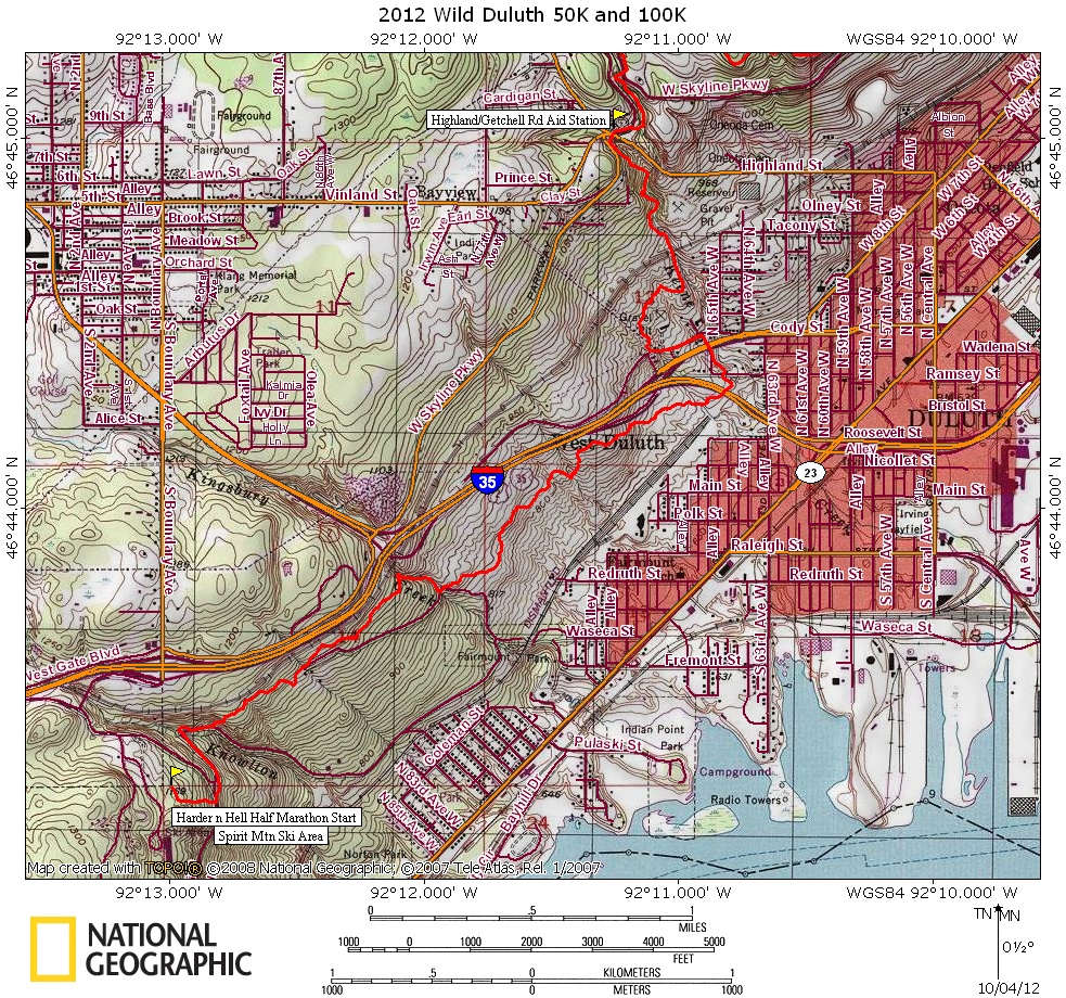
Runners will start in the large gravel parking lot just north of the main lodge at Spirit Mountain near the Superior Hiking Trail trailhead. Runners will leave the parking lot on a dirt ski hill access road leading them steeply down the ski hill. At the intersection with Old Skyline Parkway, a gravel access road, runners will turn left following the orange flagging, crossing a small bridge over a ditch (be careful, the bridge is narrow and rickety) and continuing onto an old gravel snowmobile trail/road. The road is covered with debris, rocks and gravel from the 2012 flood. Continue straight in a northerly direction until you reach the bridge over Knowlton Creek and the intersection with the Superior Hiking Trail (SHT). You will now follow the SHT the entire way to the finish at Bayfront Park, being careful to follow the blue blazes and course markings.
Main SHT continues across Knowlton Creek Bridge. Main SHT crosses bridge, turns right, and follows road downhill for 0.1 miles. SHT turns left and ascends steep hill on 138 steps. Do not miss this sharp left turn off of gravel road. After passing through nice maple grove, SHT continues through forest mixed with open meadows and rock outcrops.
SHT comes to Kingsbury Creek and turns right following Duluth's Kingsbury Creek Trail 0.2 miles downstream. Trail reaches old road and turns left and crosses Kingsbury Creek on bridge. Main trail continues straight across old road and enters woods again, going through mixed forest with rocky outcrops.
SHT crosses snowmobile bridge with metal guard rails at 68th Ave W Creek and then enters aspen-birch forest alternating with open fields. Trail crosses 62nd Ave W Creek and then the West Branch of Keene Creek. After crossing creek SHT goes under elevated I-35 on old road, turns left (don't miss this left hand turn) and climbs hillside and travels through woods to Cody Street. Trail crosses Cody Street (be careful crossing this street) and follows N 66th Ave W for one block, then turns left and follows Westgate Blvd for two blocks. SHT turns right uphill following snowmobile trail for 200 feet, turns right, crosses powerline and heads into alder woods.
SHT reaches main branch of Keene Creek and follows creek upstream. Trail climbs steeply to cross Highland Street and Skyline Parkway over a guard railing and continues to parking lot and Aid Station #5.
SHT leaves parking lot on east end, crosses Skyline Parkway and comes to old historic bridge over Keene Creek. Trail crosses bridge, turns left onto singletrack and continues upstream past old pump house and scenic waterfalls. Trail crosses Skyline Parkway again and enters forest.
SHT enters Brewer Park and travels through maple-oak forest. Trail continues along Brewer Ridge for 1.4 miles with great views. Trail descends from ridge, crosses under powerlines and turns right following snowmobile trail and reaches Merritt Creek.
After crossing Merritt Creek on two culverts, SHT crosses Haines Road (Be very careful crossing Haines Road - traffic goes fast here!) and enters predominately maple forest crossing Piedmont Ski Trails twice and then climbs to Ski Trail Knob with great views. Trail crosses North Branch of Merritt Creek and climbs to Fire Ring Knob
After descent from knob SHT climbs to Grassy Knob and then continues to Piedmont Knob 1,300 feet in elevation with Lake Superior below at 602 feet. Trail descends and crosses Skyline Parkway.
After crossing Skyline Parkway, SHT descends through alder thicket passing Aspen Knob and continuing through alders. Trail comes to clearing and turns left following old road by enclosed city water reservoir. SHT crosses N 27th Ave W and continues straight on W 10th Street for one block until just past the street sign for Lincoln Parkway. SHT turns sharply left into woods (don't miss this turn!). Trail crosses branch of Miller Creek, crosses N 25th Ave W, crosses Lincoln Park Drive, and then crosses bridge over Miller Creek. After bridge, SHT turns left and follows Duluth's Miller Creek Trail upstream to N 24th Ave W and crosses street at an angle to the left to parking lot and Aid Station #6.
SHT leaves aid station and follows Skyline Parkway on sidewalk crossing Piedmont Avenue on bridge. Trail continues along road for 200 feet past bridge and then bears right through wooded field. Trail continues through field and then enters woods coming to the "Forgotten Park." SHT descends hill and crosses Coffee Creek. Trail continues through pine trees, open meadows with great views, crosses Skyline Parkway, goes a short distance through woods, and crosses Hank Jensen Drive.
After Hank Jensen Drive, SHT follows left side of Enger Tower Road for 80 feet. Trail goes along edge of flower bed and then turns sharply left and follows Duluth's Enger Park Trail. After passing spur trail SHT continues through pine woods, passes historic Peace bell (be sure to ring it!), and follows "Scenic View" trail down to Skyline Parkway. Trail crosses Skyline Parkway. Cross Skyline Parkway and an angle to the right. Main SHT goes to right after Skyline Parkway and enters birch woods by yellow metal post through small boulders. Trail meanders through woods, crosses W. 5th St, and enters Duluth's undeveloped Central Park. Trail continues downhill through woods dotted with rock outcrops and nice stand of jack pine.
SHT crosses W 3rd Street, continues downhill through woods and turns left and then left again to follow along rock ledge above old quarry with views of harbor. Trail comes to N. 14th Ave. W., turns right and follows avenue downhill for 325 feet crossing W. 1st St. Trail enters woods again by three small boulders and goes though Duluth's Point of Rocks Park. Trail descends series of rock steps through woods, then descends from rocky ledge turning right onto old asphalt pad. Trail heads diagonally to right across asphalt pad, enters woods again, turns left, and follows with good views of harbor.
SHT crosses Glen Place and then crosses W. Michigan St. to bus stop bench. Trail turns left and travels 0.1 miles to I-35 overpass. Trail turns right, crosses I-35 on pedestrian overpass, turns left and descends long concrete ramp, and then travels on asphalt path under elevated I-35 to Railroad Street.
SHT crosses Railroad St., turns left and follows sidewalk 0.1 miles along Railroad St. Follow the sidewalk around the perimeter of the playground parking lot going right at S. 5th Avenue W and following the sidewalk to the end of the parking lot. Turn right onto paved trail entering Bayfront Park towards large arch for Bayfront Park. Pass under the arch and finish line of the Wild Duluth 50K. You are now finished!
Harder 'n Hell Half Marathon Maps (click on maps to enlarge):
Harder 'n Hell Half Marathon Profile:

Start to Highland/Getchell Aid Station:
Highland/Getchell to N 24th Ave W Aid Station:

N 24th Ave W to Finish at Bayfront Park:

No comments:
Post a Comment